The way you trek in 2026 will be different. A larger variety of hikers can now enjoy the woods, breathtaking views, and distant summits that were before reserved for a small group of professional mountaineers thanks to the opening of these trails. Hikers seeking breathtaking alpine scenery free of throngs of tourists at every peak can make a beeline for Kashmir's Tarsar Marsar and Sikkim's Goechala. Serious hikers and travelers looking for a complete, practical, and 2026-up-to-date map of those trails should consult this guide. Learn about the trail's personality, seasonal realities, a six-month fitness schedule, potential gear costs, and the growing importance of the months of July and August for high-altitude success.
The continued significance of the peculiar peaks
At unusual altitudes, the vibe is different. In contrast to the well-known routes, these lesser-known ones are more challenging to navigate, encourage more quiet, and provide more secluded vistas. Not only are Tarsar Marsar and Goechala geographically distant, but they are also culturally, ecologically, and logistically distinct. Long alpine meadows, lakes surrounded by steep ridgelines, and starry evenings are there along any route. All things considered, these are instances in which reaching a high ridge is really worthwhile.
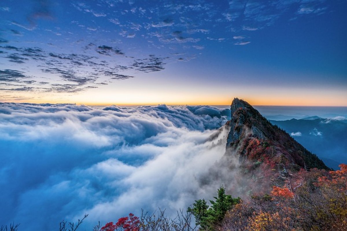
One of Kashmir's high-meadow circuits is Tarsar Marsar.
The classic alpine circuit known as Tarsar Marsar winds its way through Kashmir, linking two emerald-blue alpine lakes, expansive meadows, high passes, and a picturesque loop that highlights the interior mountains of the state to its fullest. Travelers often embark on the walk from the Kashmir valley side, navigating through pine forests and shepherds' trails en route to expansive alpine bowls teeming with June wildflowers. Campsites near Tarsar or Marsar lakes are popular with hikers, and the route's highest passes are often between 3,500 and 4,000 meters.
Only those in excellent physical condition who have already completed multi-day hikes should attempt the trip. The terrain varies from gentle meadows to occasional scree slopes and hard, rocky climbs. When the weather is clear, getting about is a breeze. On the other hand, snowfields can persist on higher passes far into summer, and weather conditions can shift suddenly. You can get help deciding on a route, locating water sources, and selecting a campsite from local guides and experienced groups. If you want to visit the less traveled sections of the circle, hiring a guide is your best bet. There has always been a sweet spot for viewing and accessing the meadows in the middle of summer, between the end of June and the beginning of September.
Get to Goechala by taking the Kanchenjunga route or the Sikkim alpine route.
Goechala (sometimes written Goecha La) is a top high-Himalayan hike in eastern India. The trail winds its way through rhododendron trees until emerging into high meadows at Dzongri. It culminates at a high col, offering a first glimpse of Kanchenjunga and its surrounding peaks. Difficult ascents, long days of trekking, and breathtaking scenery are all part of the journey. Camps are farther apart and fewer people are on this high-Himalayan route than on many others.
The Goechala path resembles the Alps in its later stages; the ascent is tough, and you'll need to spend some time at lower elevations, such as Yuksom and Dzongri, to acclimate to the higher altitude. Spring (April–May) and fall (September–November) are typically the greatest months to visit due to the pleasant weather and beautiful scenery. Even though the path is beautiful in the shoulder seasons, high passes may be closed by substantial winter snow and monsoon rains can be particularly severe in some places. The local government's camping regulations and permits serve to preserve the area's natural beauty and prevent it from being overly congested during peak seasons.
In 2026, what have the routes altered and what have they stayed the same?
Thanks to advancements in weather prediction, navigational technology, and lightweight gear, many routes are now safer. Weather remains the most unpredictable aspect, altitude sickness is a genuine and universal problem, and careful logistical planning is required in distant regions. Nevertheless, there are some things that will never change. While 2026 brings improved trail reporting from local operators and more up-to-date meteorological data, trail conditions are still impacted by factors such as the timing of snow melt, changes in the monsoon, and the accessibility of local infrastructure like roads and bridges.
An intriguing trend is the extension of the time that certain mountain routes can be traversed during the monsoon season. Particularly in regions that have less precipitation due to melting and drainage patterns, or those that are in the shadow of rain, this is the case. Environmental and operational concerns are addressed by this advancement. In the past, certain routes could only be used in the spring and fall, but with improved trail maintenance, seasonal route adjustments, and more local resources for camp management and emergency response, they are now accessible in late July and August as well. There are now safe walks in July and August when the weather is excellent, according to sources that study trekking choices during the monsoon season. As long as trekkers follow local recommendations, of course.
Justification for the shift of peak season to July and August
July and August are quickly becoming the most popular months for many Indian high-altitude climbs, and for good reason.
To begin, the monsoon is a complex and regionally variable phenomenon with complex patterns in many regions of the world. Summers in some high-altitude regions are less wet and more verdant because they are in rain shadows or receive less heavy rain for longer periods of time. This means that, unlike in valleys hit by significant monsoon rain, these trails are teeming with alpine flowers and flowing water, and thus trail damage is less likely to remain for a long period.
Second, historical snowmelt and weather events have occurred at different times due to climatic shifts. Midway through summer, stable weather patterns are becoming more typical in some parts of the Himalayas, while snowlines are receding earlier in other regions. This means that by July, many high meadows are less heavily covered in long-lasting snow, making them more accessible.
The third improvement is the enhanced operational readiness. Guidelines for monsoon-season hiking have been developed by local groups, trekking companies, and park officials. Improved route marking, improved camp drainage, and closer collaboration with locals to create safe paths are all part of these regulations.
Last but not least, the operation of calendars is significant. During the summer, when most people are off from school, vacationers often have similar likes. Trekkers who typically schedule their journeys for the spring or fall can now effortlessly arrange expeditions for July and August thanks to improved logistics. The beautiful summer foliage and relative lack of tourists at higher elevations are perfect for them.
Despite these facts, July and August are not necessarily the best or safest months. Your group's and operator's abilities, as well as local weather predictions and microclimates along the route, will determine the best course of action. When the weather and trails are suitable, though, July and August are great months to go trekking.
Six months to prepare your physique for fitness
Gradual overload, routines, and consistency will have you ready for weird high-altitude summits. Without overtraining, you can improve your aerobic capacity, strength, balance, and tolerance for high altitudes in just six months. This section lays forth a strategy that is both practical and risk-free. If you are under the age of 18 or have any preexisting health conditions, you should consult your doctor before beginning a new exercise regimen.
Begin performing low-impact aerobic activities three to four times weekly in the sixth month, which is base building. During the week, walk rapidly for 45 to 60 minutes; on weekends, go for a lengthy walk while carrying a hefty daypack; and do light strength training for your legs, core, and back twice a week. The likelihood of injury decreases when one is mobile and able to move about freely.
Step up your long walks and incorporate hill repetitions or stair exercises in month five, which is called the endurance ramp. Every weekend, try to go on a long hike—long enough to span the length of a path. You should aim for three hours initially and gradually increase it to five or six. Lunges, step-ups, deadlifts (or hip hinges), and core stability should be the focus of your two strength training sessions each week.
To prepare your body for days of trekking, begin carrying a heavier pack on longer excursions and incorporate more hiking days in a row during the fourth month, which is called load adaptation. Perform proprioception drills and balance exercises on uneven surfaces to simulate terrain that isn't flat, and keep up your resistance training with heavier weights for fewer repetitions.
In the third month, which is all about power and speed, you should conduct interval training once or twice weekly to increase your VO₂ threshold. Get in the habit of lifting weights and performing strength exercises like high-knee marches and box steps. Long, increasingly strenuous walks should continue, and you should prioritize your recuperation by getting plenty of active rest.
In the second month, known as high cadence hiking, you should concentrate on hiking with all your gear, incorporate exercises to increase elevation, and go on at least two four- to six-hour treks with a heavy pack in terrain that is comparable to your desired route. While maintaining the frequency, lighten up on the strength training a bit.
During the first month, which is called acclimatization and tapering, you should keep moving, go on short hikes, and be aware of the altitude. Before the big hike, try to get acclimatized to the altitude by planning a climb at a higher level, if possible. Rest, eat healthily, and engage in light exercise to keep your muscles and joints feeling fresh during the last week to ten days of training.
Never let your focus go from a healthy diet (ensure you're receiving enough carbs and protein), good sleep hygiene, and enough of water. If you are able to go to a higher location, try to imagine yourself at a higher altitude while you train your breathing and go on walks. For every 600 to 800 meters above 3,000 meters as you climb, add one more day to your acclimatization schedule if you're not accustomed to being at high elevations. As an enjoyable and safe way to get to a high-altitude trek, reputable preparation programs highlight orderly progressions like this one.
Competences and psychological readiness for the position
Possessing practical skills is crucial, even though most of these walks aren't particularly technical. Acquire the skill of walking securely on scree, traversing tiny snowfields, and ascending and descending steep hills using trekking poles. Camping is more enjoyable and less taxing when you know the ropes, such pitching a tent, filtering water, and navigating a multi-level sleeping arrangement. Equally important is being mentally prepared. Be flexible with your plans because of weather, cold nights, and the patience required to see gorgeous cloudy ridge lines the next day.
Managing and avoiding typical health issues
Some cases of altitude sickness are mild, causing only headaches and disturbed sleep, while others can be quite dangerous. Avoiding this is as simple as taking it easy, staying hydrated, not drinking, and having a friend keep an eye on your symptoms. Be sure you know how to get out of the secluded slopes, have the proper medication, and, if possible, a pulse oximeter. In most cases, gastrointestinal issues can be managed by adhering to safe eating habits. Always have electrolytes on hand and some basic first aid kits. It is highly recommended that you acquire travel insurance that includes high-altitude evacuation if you intend to go on a lengthy mountain trip.
Everything you'll require and how much it will actually cost in 2026
A gear's quality, weight, and price all work hand in hand. Spend a little more and hike more often, or invest in easier, longer-lasting gear that won't weigh you down. The following categories illustrate reasonable 2026 pricing ranges expressed in Indian rupees (₹). Brand, sales, and local vs. imported pricing all have a role. To assist you in managing your budget, these ranges are approximate estimates.
Any multi-day trek worth its salt requires a sturdy hiking pack with 40-60 liters of space. While there are less expensive options, investing in a well-fitting, mid-range pack that can handle heavy loads is well worth it.
Nights spent in temperatures ranging from -5°C to -10°C can be comfortably embraced by a three-season sleeping bag. Lighter but more costly are down fills, whereas heavier but less expensive are synthetic fills.
Some of the most essential pieces of clothing include a breathable, waterproof jacket and an insulated midlayer made of down or synthetic materials. A sturdy pair of trekking boots with an ankle support and traction soles is an absolute must. Boots that have been broken in are superior to brand new ones.
If you're camping solo, bring a lightweight tent, but if you're in a group, the standard equipment includes trekking poles, a headlamp, technical base layers, fast-dry trekking pants, water treatment (tablets or a filter), and cooking utensils for meals in the bush.
A GPS device, an offline map-enabled phone, and a power bank are all examples of electronics. You can save a lot of hassle on the trail with duct tape, spare laces, and a simple repair kit.
In terms of pricing, a complete set of gear, excluding airfare and tour operator fees, can range from ₹25,000 to ₹40,000 for an entry-level set to ₹80,000 to ₹1,50,000 for top-notch, lightweight gear. The price range of most mid-level full kits is ₹45,000 to ₹80,000. Retail pricing lines and real-world gear recommendations show significant disparities between entry-level and high-end performance gear, which is the basis for these calculations. Pay close attention to the details while selecting your shell, sleeping bag, and footwear for high mountain expeditions so you may maximize your comfort without breaking the bank.
Organization of a trip: permissions, guides, and local assistance
Permits are required for Tarsar Marsar and Goechala, and there are regulations in place to safeguard the environment and the public. In addition to ensuring that you camp in an environmentally responsible manner, employing local porters and expert guides will make your trip more enjoyable and safer. You may rest assured that you will reach the trailheads (which can be long and rough), enjoy secure camping, and be ready for any emergency by booking with a reliable local company. Be prepared for long days of driving on less-than-ideal roads on your way to and from trailheads. Make sure to schedule some downtime following your trip so your body can adjust.
Planned activities for a week
Any circuit would benefit from a thorough, cautious 10-day plan that would allow you to acclimate to the new setting and prepare for potential challenges. The typical itinerary includes days spent getting to the valley head, days of gradual hiking that don't climb higher than 700–900 meters in a day, days spent in mid-elevation meadows to acclimate, and days to make up for inclement weather. Progress, rather than speed, is what matters. Increasing the number of days decreases the risk and increases the likelihood of the summit.
Sustainable vacationing that has little negative effects on the natural world
However, the relative calm of offbeat mountains makes them valuable. Protecting delicate alpine meadows and water sources is the goal of leave-no-trace practices. Carry your waste with you when the time comes. Be mindful of the local pastoralists' grazing seasons and adhere to any camping regulations in your region. Taking good care of these trails now will ensure that hikers can enjoy them in the future.
Preparing for potential dangers and actual evacuations
Routes through inaccessible mountain ranges require more time for evacuation. Keep yourself informed about local resources, including the locations of hospitals and cell network service patterns. Bring a personal locating beacon or satellite communicator if you're going to be on your own. Make sure you are familiar with the locations of nearby motorable support options, such as mule farms, in case of an emergency. The wisest course of action is to descend quickly in many cases. They should act swiftly in certain situations, such as when the weather is deteriorating, a teammate is experiencing a persistent headache, or someone gets injured.
The changes that will occur in 2026 regarding summit success
Ascending to the pinnacle is no longer seen as the sole measure of achievement. Achieving safety, reducing environmental impact, and returning to host communities with meaningful experiences are all components of a successful 2026 journey. The move to the summer months is not the result of an irrational push to work harder, but rather of environmental changes and improved management. How much you plan ahead, listen to locals, and think things through determine whether an unusual peak is an exciting bonus or an unnecessary risk.
Lastly, make a mental note of everything you need to do before you travel
It is important for hikers to consider their level of physical fitness, the appropriate gear, their route, and their ability to adjust before setting out on a trip. If you have purchased boots and a shell, packed frequently, followed a six-month build, and booked through competent local partners, you have already greatly increased your chances of success. Take it easy, be respectful of the mountains, and remember that the quality of your experience, not the height you've climbed, is the true measure of your progress.